December 20, 2022
Along the Snake River.
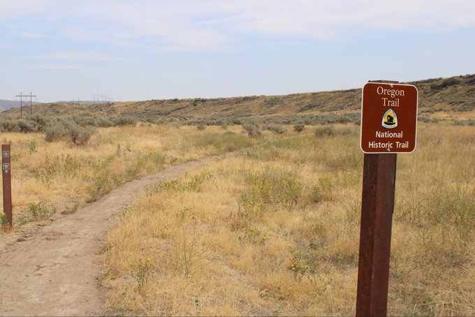
Just north of Pocatello, in Blackfoot, we paid a visit to the Idaho Potato Museum. Not only does it have a restaurant, it was surprisingly fun and interesting.

Idaho produces about 1/3 of the potatoes grown in the US, nearly all of them on land artificially irrigated from the Snake River.


In 1951, Marilyn Monroe truly did pose dressed in an Idaho potato sack, in response to a critic. One Idaho potato farmer sent her a sackful of his finest as thanks for the publicity.

We enjoyed our own potatoes, filled with sausage gravy and chili, at the museum’s small restaurant.

After we’ve returned home, my son still talks about how good the baked potatoes were.

The Tumbleweed Saloon, across the street from the Idaho Potato Museum in Blackfoot, Idaho, on the Oregon Trail.

Our next stop was the nearby Fort Hall Reservation where we visited the Shoshone-Bannock Tribal Museum – right across the street from their modern-day casino.

The Shoshone and Bannock are two distinct tribes that live in southeastern Idaho, though they share a similar language and culture.

Like many of the Native tribes of the Pacific Northwest, they fished for salmon – in their case, from the Snake River.

The Shoshone and Bannock clashed with the growing number of migrants on the Oregon Trail, but were subjugated by the army at the 1863 Bear River Massacre. They accepted a reservation that included most of southeastern Idaho, but was subsequently much reduced in size.

The Shoshone-Bannock are known for their colorful beadwork, particularly on the leather gauntlets they wear for riding and working cattle.


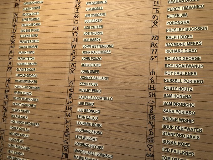
The brands used by each member of the Shoshone-Bannock tribes for identifying their sheep and cattle. Fort Hall, Idaho.
There she is, Miss Shoshone-Bannock.


Ceremonial drum, at the Shoshone-Bannock Tribal Museum in Fort Hall, Idaho.

Giant Simplot plant just west of Pocatello, Idaho. I’m guessing this is where the McDonald’s fries are made.

The Oregon Trail now followed the Snake River southwest, past American Falls. The waterfall the migrants would have seen was basically obliterated by a series of dams built in the 20th Century, part of the projects that made growing potatoes and other crops possible in the area.

The Oregon Trail emigrants would barely have believed the agricultural landscape we drove through in southern Idaho, made possible by relentless irrigation, like this potato field near Milner.

Instead, they encountered a broken, rocky landscape, with the Snake River furrowing its way through lava fields thrown up by recent (in geological time) volcanic eruptions.

When they stumbled upon the Snake River, early explorers hoped it would prove a navigable route all the way to the Pacific Ocean. Struggling through canyons and rapids, they learned they were dead wrong.

The Oregon Trail followed the southern edge of the Snake River, usually keeping it in sight.

At Massacre Rocks – where giant boulders were deposited during a massive prehistoric flood 14,500 years ago – Shoshone Indians clashed with a wagon train of Oregon-bound migrants, leaving several dead on both sides.

At nearby Register Rock, migrants again chiseled their names into the stone to show their progress. A short distance down the road, at Raft River Crossing, those bound for California would diverge to the south, while the Oregon-bound would continue to follow the Snake west.

Outside the small town of Milner, Idaho, the original wagon ruts of the Oregon Trail can still be seen, beside the Snake River.

The original ruts of the Oregon Trail, stretching into the distance near Milner, Idaho.

An irrigation canal channeling water from a dam on the Snake River, near Milner, Idaho.

Irrigating potato fields near Milner, Idaho. Central Idaho is known as the “Magic Valley” because of how intensive irrigation has transformed the previously barren landscape.

The bed of the Snake River near Milner, Idaho, with the river’s flow reduced to a trickle from crop irrigation.

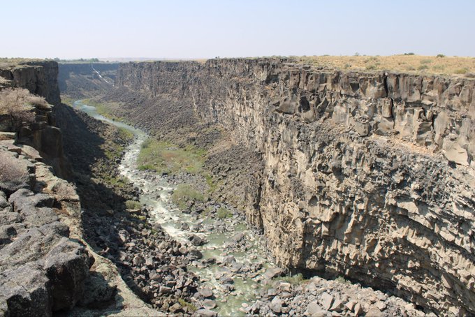
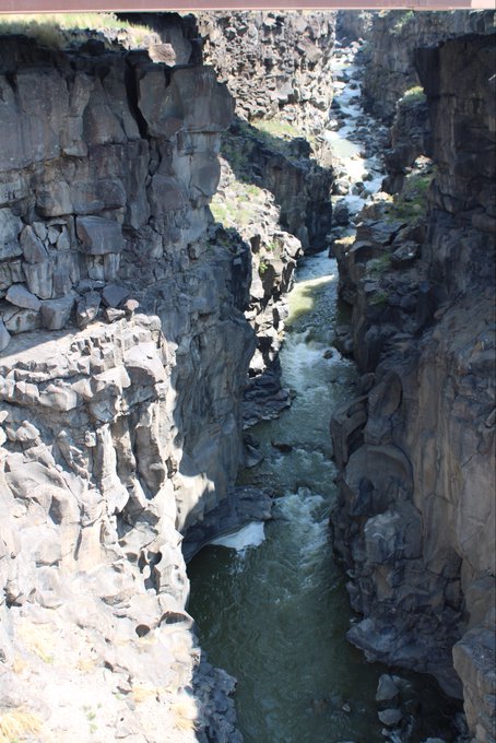
In 1811, an overland expedition to Oregon sent by fur tycoon John Jacob Astor ran into trouble at a particularly difficult stretch of the Snake River, near Murtaugh, Idaho, that they called Cauldron Linn.

With the dammed water flow, Cauldron Linn today is modest compared to the roaring rapids that must have have rushed through here at that time. The Astor Party was trapped along the Snake River through most of the winter, and nearly perished.

The gravel road down into Cauldron Linn was quite the adventure. You can see the line of it descending along the canyon cliff wall behind us.

Irrigated wheat field east of Twin Falls, Idaho. Locals told us we happened to arrive on their only day of rain all summer.

Before the Hansen Bridge was completed in 1919, east of Twin Falls, the only way to cross the Snake River in central Idaho was by ferry.

In 1927, a much larger bridge – 1,500 feet long, 486 above the Snake River below – was constructed at Twin Falls itself.

The bridge was named after I.B. Perrine, an Idaho farmer, rancher, and businessman who played a key role in the development of Magic Valley region, including the extensive dam and irrigation projects and the founding of Twin Falls as a city.

Looking down on the Snake River, including two golf courses next to its banks, from near the Perrine Bridge at Twin Falls, Idaho.

In 1974, daredevil Evel Knievel attempted to jump the Snake River Canyon at Twin Falls riding a rocket. I was only four at the time, but I totally remember that and his other crazy stunts.

Evel Kneivel’s dirt launch ramp can just barely be seen atop the distant cliff to the right. We tried to get a closer view but the site is now located within a gated community.

Evel’s parachute opened early and the rocket drifted into the valley below. As usual, he was injured but survived. Over his career, he must have broken every bone in his body, before dying in 2007, age 69, of natural causes. I remember having one of these toys as a kid.

That morning – in the spirit of Evel Knievel – we got to watch some BASE jumpers parachuting off the top of Perrine Bridge into the Snake River Canyon, a popular local activity.

A BASE jumper parachuting off Perrine Bridge in Twin Falls, Idaho.

BASE jumper coming in for a landing after jumping off the Perrine Bridge into the Snake River Canyon.

Here’s a video I took of a BASE jumper off the Perrine Bridge into the Snake River Canyon, making a near-perfect landing, at Twin Falls, Idaho.
A short distance to the east is Shoshone Falls, which drops 214 feet, a bit higher than Niagara (though not nearly as wide). The water flow is somewhat stronger in the Spring, but it was still majestic.

Looking west from Shoshone Falls. This is where Evel Kneivel tried to jump the Snake River Canyon.

Joseph Smith was wrong: The Garden of Eden wasn’t in Independence, Missouri. It’s a Shell gas station outside of Twin Falls, Idaho. It even has a serpent.


A short distance from Twin Falls, Idaho, north of the Snake River, are the remains of the Minidoka internment/concentration camp, one of the remote locations where Japanese-Americans were packed off and sent during World War II.

Today the National Park Service maintains a visitor center and small museum in the camp’s former maintenance shop, documenting the experience of the Japanese immigrants and their US-born children displaced and imprisoned due to wartime prejudice and hysteria.


The camp at Minidoka was a lot larger than the few remaining buildings suggest, with a population of about 9,000 people forcibly relocated away from their homes and businesses along the Pacific Coast.

These weren’t death camps. But the conditions were extremely isolated and spartan. And the psychological toll of being singled out and ripped away from their lives, their loyalty questioned, was a heavy burden.

A mock-up of living quarters at Minidoka, at a community museum further west in Idaho. Japanese-American “evacuees” were told they could bring only personal belongings that could fit in a single suitcase. Multiple families had only curtains as privacy in the barrack-like dorms.

The baseball diamond at Minidoka. The Japanese-Americans interned there formed a team and particularly enjoyed the opportunity to travel outside the camp for games with other local teams in central Idaho.

This used to be the swimming hole at Minidoka, where Japanese-American families gathered to keep cool in the hot Idaho summers. The winters, on the other hand, were extremely cold with little heat or insulation.

The younger inmates at Minidoka were eventually given the chance to enlist and fight for their country, in all-Japanese units that mainly fought in Europe. Some, bitter at their family’s treatment, refused and were jailed. But many others, listed here, volunteered and served.

Later, at a cultural center in western Idaho, we picked up these “trading cards” of some of the Japanese-Americans who served their country in WW2, despite how their families were treated at home. They tell their stories on the back.

As the war progressed, and hysteria subsided, the inmates of Minidoka were allowed to work outside the camp as farm laborers. After the war, some settled in rural Idaho, fearful of returning to the places they had been forced to leave.

When the war ended, the Japanese-Americans once confined to Minidoka walked out past the front guard house carrying $35 and a train ticket home. That’s all the compensation they received for decades.

In 1988, President Reagan signed a law formally apologizing to Japanese-Americans for their confinement during WW2. It provided compensation of $20,000 each, but only to immediate survivors, few of whom were still alive.

Sheep farm outside of Twin Falls, Idaho.

Back through Twin Falls to catch the stagecoach west.

No vacancy at the Oregon Trail Motel in Buhl, Idaho. Must be too many “imaginary friends” visiting.

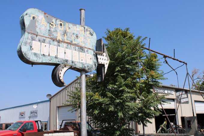
We found the real Gasoline Alley along the Oregon Trail in Buhl, Idaho.
Waterfalls sprouting from the canyon walls along the Snake River, towards Hagerman, Idaho.

Spotting Bigfoot on the side of the road, near Hagerman, Idaho.

The Oregon Trail here rises over the hills on the southwestern side of the river that comprise Hagerman Fossil Beds National Monument.

The Hagerman fossil beds are famous for the early horses found there, as well as camels, mastodon, sabre-tooth cats, and something called a “bone-crushing dog”. Sounds like a rough neighborhood, a few million years ago.

Like Fossil Butte back in Wyoming, the migrants on the Oregon Trail climbed up and over these prehistoric remains at Hagerman without ever realizing they were there. (So could we – the museum displaying the fossils just reopened a week after we passed through).

But still, what an amazing vista they saw atop the Hagerman Fossil Beds, looking over the badlands of southern Idaho.

If you look closely, you can just see the original wagon ruts of the Oregon Trail cresting the hilltop, atop Idaho’s Hagerman Fossil Beds.


If you’re on the interstate, on the other side of the Snake River, you might pass right over stunning Malad Gorge, in Thousand Springs State Park, without even glancing at it.
Literally right underneath the bridge carrying the interstate over Malad Gorge lies “Devil’s Wash Bowl”.
West of Hagerman, the Oregon-bound wagon trains faced a choice. The most direct route required making the dangerous Three Island Crossing of the Snake River, at present-day Glenns Ferry.

“Dedicated to those who keep moving forward to complete the journey.” Glenns Ferry, Idaho.

As we approached the visitors center at Glenns Ferry, we encountered a surprise: a vineyard.

A helpful map of Three Island Crossing. The current of the Snake River here was very strong, and could easily topple the oxen or the wagon, sending it tumbling downstream and possibly drowning anyone on board.

The Native tribes here – the Bannock, Shoshone, and Paiute – knew the Three Island Crossing area very well. In addition to hunting salmon, they dug here for camas root, their staple food.

In the early years of the Trail, before relations frayed and tensions mounted, the local Indian tribes often helped the arriving migrants identify the location of the best points to make the treacherous crossing.

I had to go hunting a bit on foot to find where the Oregon Trail actually emerged from the river ford.

This is Three Island Crossing, seen from the northern, destination side (they forded south to north).

Slightly upstream to the left is where Gus Glenn established a ferry in 1869, partly to assist emigrants but mainly for freight, thus giving the town its name.

The main path of the Oregon Trail then heads northwest from Three Island Crossing to Boise.

Some, however, did not want to brave the “wet” route across Three Island Crossing. Instead, they chose the “dry” route, continuing along the south bank of the Snake River.

The “dry” route soon led to the Bruneau sand dunes. Water for oxen was awfully hard to come by here.

Tracing a path through the Bruneau Dunes, Idaho.

Huge sand dunes looming over one branch of the Oregon Trail, south of the Snake River in southwest Idaho.

We caught up with the original ruts of the Trail again in a most unlikely place: a suburban housing development, on the southeast edge of Boise, Idaho.

There are a tangle of trails that come down into the Boise river valley, and are preserved amid the new residential development.
Original wagon ruts of the Oregon Trail, arriving from the south into Boise, Idaho.

The Idaho State Capitol in the center of Boise.

That night we explored an unexpected side of Boise: the city’s Basque food and culture. Croquetas, calamari, and a chorizo/manchego sandwich.


Boise has the largest Basque population outside of Spain. What brought them to Idaho? Mining and sheep. Makes sense, really.


In fact, the restaurant owner’s grandfather came to Idaho from Spain in the 1800s hoping to find silver. He didn’t, but knowing he was Basque someone offered him a job herding sheep. Truth is, he came from the city and didn’t know a thing about sheep. He learned, though.

The journey continues here in Part 10: To the Whitman Mission.
[…] The journey continues here in Part 9: Along the Snake River. […]