December 20, 2022
Busted Wheels.
We’ve rejoined the Trail again, at the town of Pendleton, Oregon.

The Working Girls Hotel in Pendleton, Oregon used to be a … well, I guess you can figure that out. I just hope they got new mattresses.

The hotel is associated with Pendleton Underground Tours. Apparently there’s a warren of subterranean saloons, gambling dens, and barracks for Chinese workers, under the town’s streets. Unfortunately, it’s by appointment only and we just weren’t sure when we’d be passing through.

Pendleton Woolen Mills. Supplied, I suppose, by all those sheep we’ve been seeing along the Trail.

The Oregon Trail continued west, crossing the Umatilla River at the small town of Echo. I read there’s a replica of the tiny Fort Henrietta that guarded this ford – basically a 2-story wooden tower – but I could find it.

At this point we faced a somewhat challenging choice. We could zip down the interstate to the Columbia River, or we could try to trace the original path of the Oregon Trail across the sparsely inhabited hills.

We headed off down the encouragingly named “Oregon Trail Road”, to attempt the authentic overland route.

Down a side dirt road we found Echo Meadows, a popular campsite on the Oregon Trail after crossing the Umatilla.

Much of the Oregon Trail here is hard to follow, because modern wheat fields and wind farms have blocked the way. Without much warning, paved roads turn to gravel and dirt, and you hope the next stretch gets better, not worse.

It was a long, long stretch of road crossing eastern Oregon, well out of sight of the interstate or the Columbia River.

But this was the eastern Oregon that the migrants saw, mile after mile of it, so close but still so far from their destination.

Did I mention that there are lots of wind farms in rural Oregon?

Somehow we made it to the tiny hamlet of Cecil, on a creek valley crossing by the Oregon Trail.

100-year-old ranch at Cecil, Oregon, along a remote stretch of the Oregon Trail.

Saying hello to a horse in Cecil, Oregon.

A field of cultivated sunflowers at Cecil, Oregon. The Oregon Trail climbs out of the valley up the hills behind it.

Sheep at Cecil, Oregon, along the Oregon Trail. Boy did they smell.

Following the Oregon Trail up the slope out of Cecil, Oregon.

The Trail ran next along desolate Four Mile Canyon, heading to the rendezvous with the Columbia River, still well out of sight ahead.

The original wagon ruts running through Four Mile Canyon, a remote stretch of the Oregon Trail in eastern Oregon.

And then it happened. You see that big sharp rock in front of the car? Well, getting back into the car, I didn’t. And I ran over it with both left tires, and giant thud.

We punctured both left tires, front and rear. I was surprised to find the rental car had no spare tire, just a sealant kit. It did no good. We were stranded in Four Mile Canyon, out of cell phone coverage.

Fortunately a man came by and gave a ride about 11 miles down the road to the small town of Arlington, by the Columbia River and the interstate highway, where we could call for a repair or a tow.

It was Sunday, and almost no tire or repair shops were open. After waiting several hours on hold (and getting a motel room so we could wait and recharge the phone), we were informed a tow was being sent.

But then it was cancelled! They later informed us this was because they couldn’t find an open towing company after all.

So we were stuck at the roadside motel in Arlington, swatting the flies in our room, until we could try again the next morning to find some help. But we were both safe, which is what really mattered.

The next morning, I got hold of a tire repair shop just in town. We went back out to Four Mile Canyon and took the wheels off.
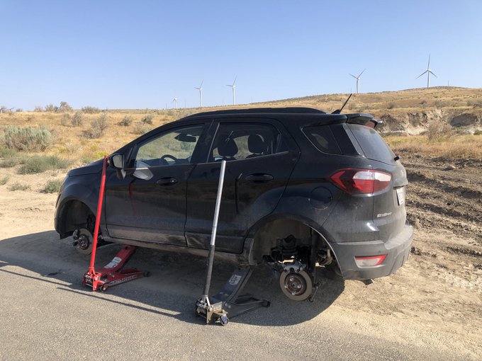
But when we got back to the shop, he didn’t have those tire sizes in stock. He had to call around and found them in another town an hour away. His daughter picked them up and he met her halfway.

Around noon – 24 hours after our “incident” – we got the new tires on and were back in business. But we won’t be forgetting Four Mile Canyon anytime soon.

At modern-day Biggs Junction, the Oregon Trail descended from the hills and the emigrants got their first glimpse of the Columbia River.

Racing a freight train along the Columbia River. It feels good to have tires again.

A few miles to west, the emigrants crossed the mouth of the small Deschutes River as it flowed north into the Columbia.

Our next stop was the former site of Celilo Falls, at one time the prime Indian fishing grounds for the entire Columbia River. The waterfall was submerged completely when The Dalles Dam was built in 1957 – a move that was fiercely opposed by local Indian tribes.

Celilo Falls attracted thousands of Native Americans each year to catch salmon, and became the trade nexus for the entire region. Before European diseases decimated them (killing 80-90%), this trade made the tribes in the Pacific Northwest wealthy and powerful.

People relaxing along the Columbia River, at the former site of Celilo Falls.

A photo at the Columbia Gorge Discovery Center, at The Dalles, showing what Celilo Falls looked like before the dam was built.

The Dalles Dam on the Columbia River, built in 1957 and operated by the US Army Corps of Engineers. It’s 200 feet tall, nearly 9,000 feet long, and generates almost 2,000 megawatts of electricity.

The Dalles are a bend in the river as it enters the Columbia River Gorge. Its name comes from French fur traders, calling it the equivalent of “the Dale” because of the rapids along the stretch, starting with Celilo Falls.

We learned about the area’s prehistory at the Columbia River Gorge Discovery Center. The gorge was formed during the last Ice Age, when huge floods from melting glaciers carved a path through the Cascade Mountains.

Prehistoric giant beaver skull from the Columbia River Gorge, compared to a modern beaver skull.

Indian basket for collecting acorns, at the Columbia River Gorge Discovery Center at The Dalles, Oregon.

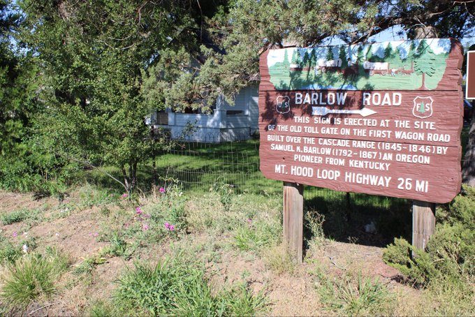
When they reached The Dalles, travelers on the Oregon Trail faced a choice. They could float down the Columbia River Gorge or, starting in 1846, they could take a toll road that had been cleared through the Cascade Mountains.

These good people have put their wagon on a raft and will be braving the rapids. We will connect with them later when we double back up the Columbia River Gorge.

But first we’re retracing the old Barlow Toll Road, which will take us up and around Mount Hood.

That means back up to the brown sunburned hills of inland Oregon.

Mount Hood looms over the distant horizon to our right, as the land rises.

Then the road quickly descends down a canyon into Tyge Valley.

A side road indicates the direction of the Barlow Road. It’s not where our GPS route to Mount Hood is telling us to go, but we take it, and it climbs up over the Tyge Valley below.

The Barlow Road takes us west to the very small town of Wamic, Oregon.

But this is the right place, because here is where the toll gate once stood. Oregon Trail migrants who wanted to avoid swimming the Columbia River Gorge had to pay for the privilege here.
The Barlow Toll Road west of Wamic, Oregon, heading straight for Mount Hood.

As we climbed toward Mount Hood, I couldn’t help being concerned. The road, while paved, was filled with giant potholes. They were circled in chalk, as a warning, but it was hard to see in the dappled sunlight and shadow before you were right on top of them.

Repeatedly, we encountered closed gates and detours, directing us down dark forest trails, where we just had to keep driving on faith it would lead somewhere.

But finally there it was, Mount Hood looming over us. Reaching 11,249 feet above sea level, it is – like Mount Saint Helens just to the north – a potential active stratovolcano, part of the Pacific “Ring of Fire”.

Migrants along the Oregon Trail rested in a meadow just under the peak. It was, literally, all downhill from here.

Descending to the west from the slope of Mount Hood. Several people have remarked to me how unusually little snow there is on top this year.

There was another toll gate along the Barlow Road here, on the western side of Mount Hood.

With the sun coming down, we reached the Tollgate Inn in Sandy, Oregon, on the approach to Portland.

The journey finally comes to an end here, in Part 12: Down the Columbia.
[…] The journey continues here, in Part 11: Busted Wheels. […]